Current Research
Using the past to inform the future:
A paleoecological perspective of the impacts of drought and fire on lakes and forests
CIMP174
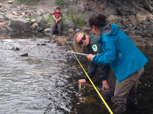
High latitude regions such as the Canadian arctic are warming at twice the rate compared to lower-latitude regions (ACIA, 2005). In addition, these regions are expected to become gradually wetter. Both temperature and precipitation play a part in shaping natural disturbance regimes, which are expected to become gradually reformed as this century continues (IPCC, 2014). In recent years, the Northwest Territories has experienced severe wildfire seasons. In 2014 alone, over 3.4 million hectares of forest were consumed by fire. This statistic is approximately 1.4 times larger than the Canadian annual average for the period of 2007-2014 (Natural Resources Canada, 2018; National Forestry Database, 2016).
Freshwater resources, such as lakes and streams, are collectively valued for their life-sustaining properties. From an intrinsic standpoint, they hold cultural and inherent significance. They are also an essential source of provisions including both drinking water and country foods. Freshwater systems support other vital services such as water-filtration, nutrient cycling, and photosynthesis. Natural disturbances have the ability to influence the accessibility and quality of freshwater resources and can potentially render them unsuitable for traditional use by communities. In addition, larger population centres, such as Yellowknife (NT), depend on the sustainability of freshwater resources for generation of hydroelectricity. In 2015 the Snare River basin, one of the territory’s largest areas of hydroelectricity generation, experienced significantly reduced energy yields due to drought-induced low water levels (Northwest Territories Power Corporation, 2015).
The focal premise of this study is to evaluate the cumulative impacts of wildfires and droughts on forests and hydrology in Southern zones of the Northwest Territories. The specific objectives for this study are as follows:
A paleoecological perspective of the impacts of drought and fire on lakes and forests
CIMP174
High latitude regions such as the Canadian arctic are warming at twice the rate compared to lower-latitude regions (ACIA, 2005). In addition, these regions are expected to become gradually wetter. Both temperature and precipitation play a part in shaping natural disturbance regimes, which are expected to become gradually reformed as this century continues (IPCC, 2014). In recent years, the Northwest Territories has experienced severe wildfire seasons. In 2014 alone, over 3.4 million hectares of forest were consumed by fire. This statistic is approximately 1.4 times larger than the Canadian annual average for the period of 2007-2014 (Natural Resources Canada, 2018; National Forestry Database, 2016).
Freshwater resources, such as lakes and streams, are collectively valued for their life-sustaining properties. From an intrinsic standpoint, they hold cultural and inherent significance. They are also an essential source of provisions including both drinking water and country foods. Freshwater systems support other vital services such as water-filtration, nutrient cycling, and photosynthesis. Natural disturbances have the ability to influence the accessibility and quality of freshwater resources and can potentially render them unsuitable for traditional use by communities. In addition, larger population centres, such as Yellowknife (NT), depend on the sustainability of freshwater resources for generation of hydroelectricity. In 2015 the Snare River basin, one of the territory’s largest areas of hydroelectricity generation, experienced significantly reduced energy yields due to drought-induced low water levels (Northwest Territories Power Corporation, 2015).
The focal premise of this study is to evaluate the cumulative impacts of wildfires and droughts on forests and hydrology in Southern zones of the Northwest Territories. The specific objectives for this study are as follows:
- I) Reconstruct hydroclimatic conditions of the Snare River basin during the last ~300 years through correlations between tree growth indices, large-scale climatic indices, and regional streamflow measurements; and II) identify changes in climate through analysis of historical lake water balances.
- Describe the wildfire regime within the North Slave region, specifically fire magnitude and frequency, during the past 2000 years through high-resolution analysis of macroscopic charcoal deposited in lake sediments.
- I) Determine the effect of recent forest fires (<2 years) on stream water quality through comparison of stream water chemistry and invertebrate community metrics between recently burned and unburned stream channels; II) analyze how lake hydrology and water quality is impacted by variation in catchment characteristics and the effects of disturbances such as wildfire.
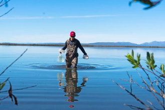
Evaluating the influence of climate and land cover changes on water and carbon balance in Old Crow Flats, Yukon, Canada
Summary from the Arctic -Boreal Vulnerability Experiment (ABoVE) website [visit]
Research affiliated with ABoVE (NASA) as of 2016
This research builds on a decade of hydrological and paleolimnological research in OCF by focusing on evaluating the influence of changing landscape features (e.g., land cover, permafrost slumping) on hydrology and carbon export in OCF and the influence of the changing OCF landscape on the Yukon River Basin (YRB). Specific research objectives for this next phase of research in OCF include a) mapping variability in land cover change over multiple spatial and temporal scales; b) identifying spatial variation in runoff generation processes and carbon export from major OCF sub-catchments; and c) evaluating spatial association of changing catchment features on lake and river water balance and chemistry. Carbon studies in OCF were initiated in 2015 when we analyzed water from 22 creeks and 14 lakes for isotopic compositions (δ13C DIC and DOC, δ18O, and δ2H) and a suite of water chemical parameters including DIC and DOC concentrations. Mapping of coupled results are elucidating the relative importance of different thermokarst geomorphic processes on exported water quality and carbon concentrations, including the influence of lake drainage and retrogressive thaw slumping along the Old Crow River network. Land cover and permafrost retrogressive thaw slumps are bein ng mapped using UAV and ground surveys (GPS, vegetation, and active layer properties) in selected areas. UAV surveys are also being used to calculate the amount of material being exported from retrogressive thaw slumps to the Old Crow River, which is of particular interest to the community of Old Crow. The ABoVE airborne campaign will provide catchment-scale data required for estimating hydrological conditions of lakes and rivers downstream from varying land cover compositions and active layer characteristics
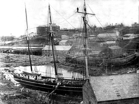
Excavation of the Shickluna Shipyard
Summarized from The Brock News (2019)
"A research team led by Brock University archaeologist and maritime historian Kimberly Monk aims to uncover an abandoned shipyard built by a Maltese immigrant in the 19th century, along with workers’ cottages and even the hull of a ship.
Monk’s project will see a team of archaeologists, historians, geographers and geophysicists from three Ontario universities and their students excavating and documenting the Shickluna Shipyard, which operated from 1838 to 1891 along St. Catharines’ Twelve Mile Creek. Shipyards form an important part of the maritime landscape but opportunities to study them are rare, says Monk, Professor of History"
Future ArcTic Ecosystems (FATE)
In conjunction with the McMaster Ancient DNA centre and the University of Alberta Tephrochronology lab, we are utilising multiproxy palaeoenvironmental records from Gravel Lake, central Yukon Territory, to investigate the environmental response associated with the disappearance of megaherbivores at the end of the Pleistocene. Palynological analyses of pollen and coprophilous fungi are in progress at the Brock University Water and Environment Laboratory alongside magnetic susceptibility (MS). We have identified pollen in standardised counts of 300 per sample with further identification of pigmented fungal spores, particularly those known to be obligate coprophilous genera. Coprophilous fungal spores have become increasingly utilised as proxies for megaherbivore abundance in Late Quaternary samples and appear throughout the samples from Gravel Lake. Sporormiella, Cercophora, Podospora and Sordaria appear to be the most common taxa with several other genera appearing within the sediments. We aim to combine results of abundance and disappearance of obligate coprophilous spores, sedimentary ancient DNA, and an established chronology to identify the timing of local megaherbivore extirpation. The Arctic is currently undergoing dramatic changes that directly impact the stability of ecosystems and northern landscapes. Rapid climate change during the Late Quaternary caused numerous ecosystem responses, including altering vegetation assemblages and possibly contributing to the mass extinction of numerous megaherbivore taxa. This study aims to highlight the direct impact of climatic amelioration on megaherbivore populations with intentions to provide another dataset of biodiversity alteration from which analogues of modern ecological responses to current and future anthropogenic warming can be based.
In conjunction with the McMaster Ancient DNA centre and the University of Alberta Tephrochronology lab, we are utilising multiproxy palaeoenvironmental records from Gravel Lake, central Yukon Territory, to investigate the environmental response associated with the disappearance of megaherbivores at the end of the Pleistocene. Palynological analyses of pollen and coprophilous fungi are in progress at the Brock University Water and Environment Laboratory alongside magnetic susceptibility (MS). We have identified pollen in standardised counts of 300 per sample with further identification of pigmented fungal spores, particularly those known to be obligate coprophilous genera. Coprophilous fungal spores have become increasingly utilised as proxies for megaherbivore abundance in Late Quaternary samples and appear throughout the samples from Gravel Lake. Sporormiella, Cercophora, Podospora and Sordaria appear to be the most common taxa with several other genera appearing within the sediments. We aim to combine results of abundance and disappearance of obligate coprophilous spores, sedimentary ancient DNA, and an established chronology to identify the timing of local megaherbivore extirpation. The Arctic is currently undergoing dramatic changes that directly impact the stability of ecosystems and northern landscapes. Rapid climate change during the Late Quaternary caused numerous ecosystem responses, including altering vegetation assemblages and possibly contributing to the mass extinction of numerous megaherbivore taxa. This study aims to highlight the direct impact of climatic amelioration on megaherbivore populations with intentions to provide another dataset of biodiversity alteration from which analogues of modern ecological responses to current and future anthropogenic warming can be based.
Southern Forests Water Futures
Summarized from Global Water Futures Website
"Forest ecosystems cover about 40% (397 Mha) of Canada's surface area and play a major role in providing sustainable water resources and healthy environments for communities in cold regions in Canada and across the world. A large portion of these forests (230 Mha) has traditionally been managed or harvested for wood production and resource extraction – practices which can impact regional water resources. Forest management has evolved from stand replacement practices to reduced disturbances such as thinning or regeneration enhancement methods. The impacts of these partial canopy disturbances on processes affecting energy, carbon and water balances are challenging to observe and quantify. In addition, climate change and extreme weather events introduce additional stresses that can impact forest growth, composition, water budgets, resilience and overall survival. In southeastern Canada, large population centres and industrial, municipal and agricultural land use activities put a strain on forest ecosystems and local water resources, which will be further complicated by future climatic changes.
The proposed work will develop and improve process-based land surface and ecosystem models (e.g. Canadian Land Surface Scheme-Canadian Terrestrial Ecosystem Model (CLASS-CTEM) and Boreal Ecosystems Productivity Simulator (BEPS) to more accurately account for cold region processes, through development and testing of new novel canopy conductance, evapotranspiration and ground water interflow algorithms. This modelling work will help to improve the predictive capabilities of the Canadian regional and global climate models. BEPS is incorporated in the Canadian regional (Global Environmental Multiscale Model, (GEM)) model and CLASS-CTEM is used in the Canadian Earth System Model (Can-ESM). Project data will be available to Canadian and international user communities and to the public through GWF Big-Data archive."
